
Pumicestone Passage: a double-ended Barrier Estuary
- Matt Owen
- Sep 21, 2021
- 4 min read
A two-part feature on our local history by Mij Na-Rod (#facxual_events), a time-travelling observer caught in a constant state of flux, warps and wormholes. He is also prone to drinking on the job, thus getting his facts confused.
Part One
Pumicestone Passage was believed to have been created around 5,000 BC when the sea level rose from the last Ice Age. Whilst Egyptian pyramids were somehow built moving huge sandstone blocks weighing up to 2.5 tonnes, in Australia waterways and islands were being created by the movement of sand.
Bribie Island was formed during the transfer of sands moving from south to north with the changed current direction. During this formation it was possible that openings or passages had existed in a number of locations along the island. Some of these positions are probably indicated by the location of islands in the Passage which may have generated at the outlet to the ocean or simply at the head of a creek.
Pumicestone Passage is a double-ended Barrier Estuary between Bribie Island to the east and the mainland to the west. The narrow neck of Bribie has always been subject to potential tidal breach, and in geological terms the island is ephemeral (short-lived) so it is expected that the spit will vanish at some time. Maybe even in our lifetime.
Every day, photos of sunsets, sunrises, the Bribie bridge, pelicans and dolphins are posted all over social media. But who was here first? Whose footprints first broke the sand on the beach?
Who were the first white explorers? And how did the name of the passage eventuate?
In the beginning, the Bribie Bin Chicken (Threskiornis molucca Bribis) roamed the island carefree and fancy-footed. Even this bird has evolved after centuries of living on a sand island scavenging for food. The Ibis of today lacks the pectinate claw on the middle toe of each foot. This foot digit is longer and oddly called “Moreton Toe” when first discovered by James Cook – the same man who also named Moreton Bay on 15 May 1770.
Two days later, on Thursday 17 May 1770, while sailing up the east coast of Australia on HMS Endeavour, Lieutenant James Cook sighted the Glass House Mountains, so-named by him as the reflections and the shape of the hills reminded him of the glass manufacturing houses back in his homeland of England. Cook named the area Glass House Bay and was the first European to name this stretch of water.
At that time the inhabitants of Bribie Island were the Djindubari people (broadly part of the 'Kabi' or more correctly Gubbi Gubbi people).
It is believed that around 1799 the recorded pre-contact population of Aboriginal people on Bribie Island was 600 – 1,000. However, by 1891 none remained on the Island and only four lived on the mainland.
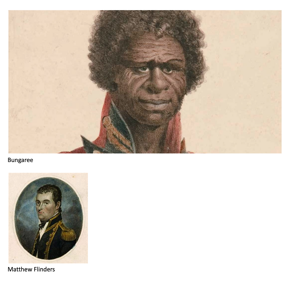
On 16 July 1799 Captain Matthew Flinders left Glass House Bay about 3.2 kilometres east of the shore in the sloop the Norfolk. He sailed south-west between Moreton Island and the mainland parallel to the southern shore of Bribie Island until spotting an opening in the low western shore. He anchored at 8:15am and transferred with a small crew, a cat and Bongaree in a small craft.
Wait - who or what is a Bongaree? Well Bongaree, or Bungaree, was an Aboriginal from the people of Kuringgai in the Broken Bay area north of Sydney, who was known as an explorer, entertainer, and Aboriginal community leader. He served Matthew Flinders for many years as an interpreter, not only on this voyage of discovery but also between 1801 and 1803 on HMS Investigator with Flinders’ pet cat ‘Trim’. Flinders described Bungaree as a "worthy and brave fellow" who saved his expeditions multiple times.
Sadly, there are no statues to celebrate Bungaree in this country. Yet you can walk the streets of Sydney and see magnificent statues of Apollo, Athena, William Shakespeare, Queen Victoria. There are three statues of Flinders’ cat Trim around Australia. But none of Bungaree! Talk about a cat-astrophe
Flinders landed on Bribie Island, unaware that it wasn't the mainland of Australia, and met a small group of Aborigines who had gathered on the beach. Although Bungaree didn't speak the same dialect as the local aborigines the meeting was peaceful until one attempted to remove Flinders' hat. Flinders refused so the Europeans and Bungaree returned to their boat. As they left the man who had tried to remove Flinders' hat threw a spear that missed any of the crew.
Flinders fired his musket at the group on shore and wounded the man who had thrown the spear. This Aboriginal was believed to be called ‘Xeyd’. His name can be translated today in Gubbi Gubbi as Cross-eyed.
The Aborigines fled the beach with Xeyd reportedly running in the opposite direction smack bang into the trunk of a eucalyptus tree. Flinders named this southern shore and site of the confrontation Point Skirmish. There is an area on the modern map marked Skirmish Point but that should not be confused with the actual place of the incident which is now known as South Point.
Flinders needed to repair leaks in his boat (possibly made by the errant spear) and pulled it ashore further up the passage. The leaks were found just below the Plimsoll Line and were plugged with a mixture of seaweed and ground pumice stone as a temporary measure. Coincidentally, a restaurant named Plimsolls once operated near this site in the 1980s – their “wilted greens” tasted a lot like seaweed. This is also the area where the Steamship Koopa served the Bongaree Jetty and began to carry visitors from Brisbane via Redcliffe.
Flinders waded some seven kilometres further north near what is now called White Patch. Historians believe that White Patch was eventually called the Town of Bribie in 1877.
Once his boat was repaired, Flinders explored the mainland side of the passage and scaled Mt. Beerburrum to get a better view of the area.
In our next issue Mij Na-Rod will recount the history from the 1800s to the present.
Comments